Showing posts with label sierra. Show all posts

Monday, July 30, 2012

Middle Palisade

I finally went back and climbed Middle Palisade. Two summers ago I walked all the way up to the base and then turned around and walked back down. A few things prevented me from climbing it then: less fitness, a late start, parking at the wrong trailhead, going the Croft way through soft moraine rather than a better way hopping over talus and slabs described on Summit Post.

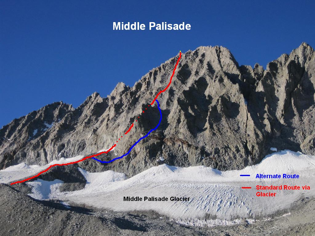
A few notes: there are a couple of variations. One describes traversing under this giant red splotch, and you can avoid the glacier, but it looked "horrendously scary" as Drew put it. We ascended via the standard, or "Secor" chute. It was fine.

I think that this climb pushed my limits mentally about as much as I'd like, and that's given that everything went smoothly. The climb is awesome, but it's super exposed and goes on and on forever. There aren't really any rests from the exposure. I got a bit burned out on it.

On the way up some folks were coming down the talus and asked us if we'd seen a "tired and lonely looking climber". We hadn't. When we got back to Finger Lake on the way back to the car, a story emerged that a 60 year old guy had started up Norman Clyde the afternoon before and had not made it back to camp, so a search was called. We ran into a few SAR guys on the way out. The mountains don't fuck around, and I have little of what people could call mountain sense. I'm a Georgia girl who moved to the Central Valley of California. Mountains are like another planet to me. Snow on mountains is like another universe altogether. I love mountains, but I don't know if I'll ever be particularly comfortable. I'm ok with that.

Today, after doing a bit of research on the missing climber and turning up a story about a guy who died on Middle Palisade a few years ago (if you fall, you aren't going to stop til you hit the bottom), I have this weird feeling that I did something kind of stupid and dangerous and got away with it. I wonder if people who make a living doing scary shit ever feel that way.

I've now summited three 14,000+ peaks in the last 10 days (plus White Mountain a few years ago). This was the proudest. Langley was a walk-up, and Russell was a lot less exposed (which is strange, since you are on a ridge), and a shorter day overall. Not sure what I'll do next.

Photos (all taken with iphone):
 We started around 6:30am

 The mountain comes into view.

 I'm always the slowest. Even though I'm in pretty good hiking shape right now, and I generally pass people when I'm on my own, Drew and Pete are fast!

 Hard to believe that it's only going to be 3rd class!

 Finger Lake is gorgeous. And named after me of course. The Croft way says to skirt left around the lake and go through a bunch of gullies. DON'T GO THIS WAY. It sucks big time. Instead, go right and end up on a ridge. The footing is far more solid, made up of talus and slabs. 

 looking down on Finger Lake

 The intimidation factor grows.

 Still intimidating.

 What's this white stuff?

 One of the few intact glaciers in California. Wonder how long it's going to last. You can see the red rock in this shot.

 So much talus/moraine

 The left glacier is still in pretty good shape.

 Still intimidating. I was kind of gripped the whole time. The formation was awesome and improbable. Like Croft says in his description, it was a lot like a staircase of little ledges. The rock was very good...but the exposure!

 Looking up the chute. I wore a helmet. We were in a giant gully after all.

 The reward: 360 degree spectacular views


 Drew lounging at the summit.

 Looking down on the gendarme. We came up and descended on the right side. I'd recommend this way.

 on the way down.

 Probably the crux of the route: stepping onto the climb from the glacier. Nobody wants to punch through and get stuck in ice.

One of the most beautiful and inviting lakes I've ever seen on the way down. Margaritas at the Mobil proved more inviting and we didn't stop to enjoy it.

Twelve hours car to car.

Saturday, July 28, 2012

Tuolumne, Langley, and the Golden Trout Wilderness

I went to Tuolumne Wed evening to climb with my friend Drew the next day. We went out to South Whiz dome and toproped a few routes. I'd tried Shadow Warrior before when I was still kind of sick and flailed. This time I flailed less and figured it out. I doubt I'll ever go back enough to send it - which would take effort and knowing the sequence. The bottom is pretty hard.

I felt like I didn't get a good enough workout, so I drove back down to Lone Pine to finish Langley, which I'd bailed on last weekend due to the weather looking ominous.  I was at the top in 5 hours, so I decided to finish a big loop through the Golden Trout Wilderness. I think the total was about 22 miles. My feet hurt.

Right now I'm hanging out in Bishop trying to decide what to do with my day. I RSVP'd for a wedding in Convict Lake this afternoon, but I'm dirty and my feet hurt. I don't really feel like being social on a good day, and I'm not a big fan of weddings. Plus tomorrow I'm supposed to do Middle Palisade with Drew and his friend Pete (and possibly S. Watson). I don't want to drive all the way up there and then drive all the way back down to the trailhead outside of Big Pine (this after I drove from the trailhead outside of Lone Pine to Bishop this morning...).

Here are the photos:

 Langley in the distance. No storm brewing today.

 Marmots: fat, lazy, and cool with it.

 Old Army pass

 Summit register

 Summit views


 Summit shot


 Heading west down from Old Army pass. An unnamed trib to Rock Creek is on the left

 This creek was really pretty - amazing that water is flowing through such dry terrain

 An attempt at an artistic foxtail pine photo. I am such a crappy photographer.


 I thought the foxtail pines were really cool.

Slogging through a sandy forest was not that cool.

 A view east from Cottonwood pass

 A grouse hen and her chick


Monday, July 23, 2012

New and Old Army passes

The road to the Whitney portal splits around Lone Pine. The left fork goes to Horshoe meadow (and two trailheads). One is the Cottonwood Lakes trailhead and the other is the Cottonwood Pass trailhead (they are almost right next to each other). This is a good place to bivy, since it is at 10,000 feet and the Whitney Portal is a fucking zoo. I camped there Friday and Saturday nights.

Sunday I wasn't sure what I wanted to do, since I was kind of tired and I had a couple of blisters on my feet. I knew I didn't want to go home yet (I was already all the way down in Lone Pine and at a trailhead). I thought I might do Langley depending on how I felt. As it turned out, the weather looked a bit ominous. I ended up going up to Cottonwood Lakes, up Old Army pass and then down New Army pass for a loop. I think the loop is about 14 miles, but I can't be sure. I know it's at least 6 to get to Cottonwood Lakes from the trailhead.

I was excited to check out Cottonwood Lakes since I've genotyped trout from there. I like to visit places that I've heard of in my work.

Photos:


 Mt. Langley is on the right

 one of the Cottonwood Lakes

Cottonwood Lake 4. You can kinda see Old Army pass on the left of the cirque 


 looking down on #4

 view west from Old Army pass (the pass is about 12,000 feet)

 looking up at Langley

 There were a lot of Sierra primrose (Primula suffrutescens) on New Army Pass


 looking down on High Lake from New Army Pass


 The foxtail pines in this area are awesome. Krummholz.


 a giant field of moraine boulders

 it was a good decision not to hike up there.

 storm over the portal


I hit a huge cluster fuck on 395 near Mammoth. It might not be apparent, but the road is covered in hail/snow/sleet. There was a storm over the whole sierra from Lone Pine to Bridgeport. I saw a lightening strike fire near the switchbacks above Mono Lake. It was DUMPING rain at Crowley Lake. I stopped there for pizza on the way home.